IRRSAT – Determination of the irrigation Factor 4 potato growth using Sentinel-1 and Sentinel-2 data

Project no. 4000121971/17/I-EF pt.: "Irrigation Factor 4 potato growth using Sentinel-1 and Sentinel-2 data". Project Category: ESA Polish Industry Incentive Scheme
Acronym: IRRSAT
Start date: 01.10.2017
Project completion date: 31.12.2020
Prime Contractor:
Łukasiewicz Research Network – Industrial Institute of Agricultural Engineering
Sub-contractors:
Institute of Geodesy and Cartography, Remote Sensing Centre,
Warsaw University of Technology, Faculty of Electronics and Information Technology, Institute of Electronic Systems
Project objectives
The main objective of the project is to create pre demonstration System for Irrigation of crop (potato) fields based on Earth Observation (EO) and in-situ data. In order to fulfil the overall Project objective, the following specific objectives of the Project need to be achieved:
- to develop and calibrate a model of soil moisture assessment based on S1 and S2 data using in situ results;
- to validate the SM model using an independent set of measurements, and assess its accuracy, applicability and limitations;
- to develop the model of irrigation factor value calculation throughout the growth period;
- to establish a soil moisture and irrigation factor as pre-demonstrator product and present it for validation (with the SM sensors) and provide dissemination between users from agriculture market.
Efficient irrigation depends on a balance between the atmosphere and soil conditions. Atmospheric precipitation and evaporation play important roles as does the water-holding characteristics of the soil. That’s why it is important to supply accurate amount of water for crop development taking into account the soil type, soil water regimes, precipitation and evapotranspiration.
The IRRSAT Project is designed to develop the pre-demonstration System for irrigation based on the fusion of in-situ (meteorological and hydrological) measurements and satellite derived data. The key benefit of the System will be the opportunity to use it for large areas or scattered fields by any farmer without the need for expensive sensor systems where water conditions are metering only in direct spot. The pre-demonstration system will be built on the basis of various, complementary data, collected in-situ manually, with the sensors installed in the ground and meteorological stations as well as satellite data.
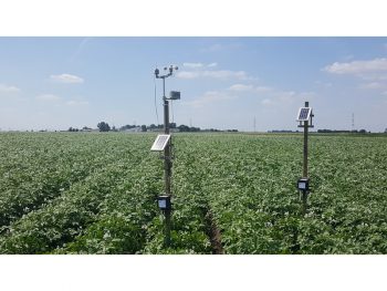
Firstly selected field will be scanned with electromagnetic scanning, which would enable to assess the granulometry of soil and thus its water capacity as well as to designate the homogenous polygons (areas of similar soil parameters) for which the soil moisture and meteorological data will be collected. Within homogenous polygons, the soil moisture and soil temperature sensors as well as meteorological stations will be installed (Łukasiewicz – PIMR). Moreover the LAI measurements will be performed. These procedures will give the information: how soil moisture varies with the change of soil texture (S1 data will refer to soil -texture polygons) and if changes of LAI values based on in-situ and Sentinel-2 data correspond to changes of soil moisture. These validations will be done for the future applications of Sentinel-1 and Sentinel-2 data without in-situ measurements of soil moisture, LAI and electromagnetic scanning. Subsequently the model of soil moisture assessment on the basis of Sentinel-1 data with the application of in-situ soil moisture data collected by sensors, will be developed.
On the basis of Sentinel-2 satellite data and LAI values measured in-situ, the LAI maps will be developed. It is found that LAI values reflects the potatoes growing stages and will be used for the assessment of the precise time of irrigation treatments. On the basis of SM map, the soil water capacity map, map of LAI, evapotranspiration and precipitation, the model for Irrigation Model will be developed and irrigation doses will be measured.
Finally a soil moisture and irrigation factor as pre-demonstrator product will be developed and presented for validation (with the SM sensors installed in the fields). Furthermore the results will be disseminated between users from agriculture market. The product as Soil Moisture and Irrigation Factor will replace the in-situ measurements of meteorological parameters and soil moisture and would enable to provide efficient irrigation and will give savings in water supply and expenses. Proper irrigation that will rely on soil moisture values in short time step will give the increase the potatoes yield what would be transferred into economic benefits.

 ALL CURRENT PROJECTS
